Use case — UK
Category A/B/C/U, stem diameter,
on the actual topo plan.
BS5837 preliminary tree surveys have their own vocabulary and their own client: a planning authority validating an application. LogLog's field record already speaks that vocabulary — it just doesn't yet produce a Tree Constraints Plan or feed AutoCAD directly. Here's exactly where it helps and where it doesn't, plainly stated.
What already matches BS5837 practice
Preservation category — A, B, C, or U — is a built-in field, not a workaround typed into a notes column. Stem diameter is recorded in centimetres, with multi-stem trees handled as a comma-joined list, matching how a BS5837 survey typically logs a multi-stemmed specimen's individual stems rather than one averaged figure.
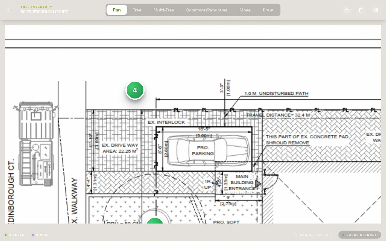
Load the topo plan or the client's own site plan PDF and pin each tree directly on it, exactly where Paul Barton and other UK consultants on the Arbtalk forum describe annotating a "marked up topo plan" today by hand. Scale calibration, either drawing a known-length line or typing the printed ratio, keeps distances on that plan honest — useful when a validation reviewer checks stem position against the drawing.
Preservation category, built in
High quality — retain wherever the site layout allows it.
BModerate quality — retain if it doesn't unduly constrain the layout.
CLow quality — retention is a lower priority against the development.
UUnsuitable for retention on condition or structural grounds, independent of the development.
Subcategories (1/2/3 — arboricultural, landscape, cultural value) record as notes; LogLog's category field is the A/B/C/U call itself.
Heritage flag and ownership
A separate heritage flag marks a veteran or notable tree independent of its preservation category. Ownership — private, neighbouring, park, right-of-way, city — matters the moment a tree sits near a boundary and a TPO or a neighbouring authority becomes relevant to the application.
Export that hands off cleanly
The export ZIP gives you a spreadsheet of every field per tree, the annotated topo plan with pin positions, and photos named by tree number — a solid package to attach to an Arboricultural Impact Assessment or hand to whoever's producing the Tree Constraints Plan.
Where it stops — say this plainly
LogLog does not calculate or draw Root Protection Areas (RPA circles) on the plan, and it does not export DWG or shapefile output for a CAD technician to open directly. If your firm's workflow depends on getting stem data straight into AutoCAD to auto-draw RPA circles, that handoff isn't built yet — the annotated PDF is a clean reference for a CAD tech to trace from, not a file they can import.
Treat LogLog today as the field data capture layer for a BS5837 preliminary tree survey — species, category, stem diameter, condition, photos, all pinned to the plan and exported cleanly — not as a Tree Constraints Plan generator or an AIA production tool.
Photographic evidence, tied to the record
A condition assessment supporting a category grading is more defensible with a photo attached to that specific tree, especially when a survey gets challenged at validation. LogLog attaches photos directly to the tree record and exports them named by tree number, so the evidence and the data travel together into the AIA package.
UK spelling and units throughout
Condition ratings, ownership categories, and measurement units follow the terminology UK practitioners already use day to day — metric stem diameter, standard condition language — rather than a US-first tool with the labels translated on top.
The old way
Notebook and paper plan in the field, then typing everything into Excel and marking up a drawing in AutoCAD afterward — time-consuming, and you still carry the paper plan on site to reference tree numbers, just in case.
With LogLog
Category, stem diameter, and condition go straight onto the digital topo plan as you walk it. The spreadsheet exists the moment you finish the last tree — no retyping from a notebook that evening.
See the full field record on tree data fields, how pin placement works on PDF site plans, and what an export contains on exports.
Field capture and CAD production stay separate jobs
Rather than trying to be the whole pipeline from field tape to finished Tree Constraints Plan, LogLog is honest about doing one part of it well: getting accurate, structured survey data off the site and into a clean spreadsheet fast. The CAD production step still belongs to whoever draws your plans today — LogLog just means they're working from a spreadsheet and an annotated PDF instead of a stack of paper notes.
Try it on your next preliminary survey.
Free forever for solo use. Load your topo plan and see if the category workflow fits.