Feature
Annotate the plan you were
actually given.
Every other tool wants you to redraw the site on a generic web map. LogLog loads the client's own PDF — the survey drawing, the architect's plan, the parcel map from the county — and lets you pin trees directly onto it. That's the whole differentiator.
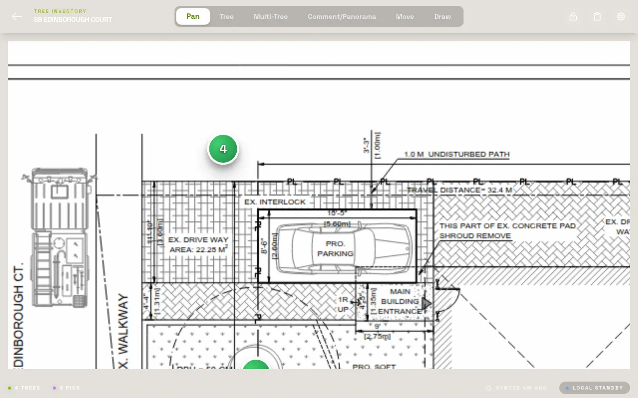
Load any PDF, any page count
Upload the site plan before you leave the office. Multi-page plan sets get a page selector, so a six-sheet drawing set works exactly like a one-page lot survey — pick the sheet, start pinning. The PDF renders through pdf.js at full resolution, so text and line work on the drawing stay legible as you zoom in on a dense stand of trees.
Pan and pinch-zoom are hand-built, not a bolted-on library — gesture handling that doesn't silently eat a tap when you're trying to drop a pin at the edge of the screen. Rotate the page independently of the PDF's own orientation if the drawing was scanned sideways; both rotations get reconciled automatically when you export.
In practice
Load the plan Sunday night. Drive to site Monday morning. Open the app, tap the plan, and every pin you drop lines up with the drawing the client already has in their file.
Two calibration modes
Line mode: draw a segment between two known points, type the real distance in meters.
Ratio mode: type the printed scale directly, like 1:100 or 1:500, if the drawing already states it.
Scale calibration, not guesswork
A site plan is only useful if measurements taken from it mean something. LogLog's scale calibration modal lets you set the real-world scale of the loaded PDF one of two ways, feeding a scale denominator into every export so anyone downstream — a planning reviewer, a CAD tech, an insurer — can trust distances read off the annotated plan.
There's also a ground control point (GCP) anchor capture, new to this version: pin two anchor points and enter the real-world distance between them, tying the PDF's pixel space to a physical reference. It's built for future georeferencing use and doesn't affect today's export — but it's there if your workflow needs it.
Numbered pins that stay linked to their record
Tap anywhere on the plan to drop a pin — the position is stored as a percentage of the page, not raw pixels, so it survives zoom and rotation math without drifting. Drag a pin to reposition it if you tapped slightly off. Each pin gets a number, and that number is permanently linked to the tree's full data record: species, DBH, condition, photos, notes, everything.
Wide-site reference photos get their own marker type — a Panorama pin, shown in purple — for shots that cover the whole property rather than one tree. Multi-stem trees get a distinct blue marker so a crowded plan still reads clearly at a glance, without opening every pin to check what it is.
A pencil marking survives fine until it rains, or until the photo of the markup comes out blurry, or until you're back at the desk squinting at your own handwriting trying to decide if that's tree 12 or tree 17. Tapping the plan directly sidesteps all three — the pin and the number are the same object from the moment you place it, not a transcription of one.
A markup layer, separate from your pins
Beyond numbered tree pins, LogLog has a freehand markup overlay for sketching directly on the plan — circling a construction zone, marking a fence line, noting where access is blocked. It's stored as its own layer, so a markup sketch never gets confused with a tree record, and toggling it off gives you a clean view of pins alone when that's what you need.
Rotation handled correctly, twice over
Scanned plans are sometimes saved sideways, and PDFs carry their own intrinsic rotation flag independent of how you'd like to view them. LogLog tracks your display rotation and the PDF's own rotation separately, then reconciles both at export time — so the annotated plan you hand to a client comes out right-side up regardless of how the original file was oriented.
Once trees are pinned, the next step is filling in the record — see tree data fields for what LogLog captures per tree. If you're working a job with no signal, read how offline mode works. Doing BS5837 work in the UK? See how the plan workflow fits a BS5837 survey.
Try it on your next plan.
Load a real site plan and see whether the pin workflow fits how you already survey. Free covers your first project, no time limit.